OASIS is an interdisciplinary project founded in 2012, aiming at reconstructing origins and evolution of the Late Roman settlement of Umm al-Dabadib (Kharga Oasis, Egypt’s Western Desert), with special attention to the organisation and nature of the associated cultivations and irrigation system. Umm al-Dabadib is located at the outskirts of the oasis’ depression, in a desert environment at the edge of the inhabitable world, where maintaining a community requested ingenuity, method and specific knowledge. Abandoned about one century after its construction, due to the desert climate and the total isolation, the remains of the architectural complex and of the irrigation system have both survived very well to the passing of time, and today offer important material for a modern investigation.
OASIS is sponsored by National Geographic/Waitt Institute and by the Italian Ministry of Foreign Affairs (Ministero degli Affari Esteri DGSP-IV), and works in collaboration with the Ministry of the Antiquities/Supreme Council for the Antiquities and the Egyptian Environmental Affairs Agency in Egypt.
OASIS completed three expeditions (2013, 2014 and 2015) and is now preparing the next, scheduled for 2016.
LOCATION AND DESCRIPTION
Kharga Oasis
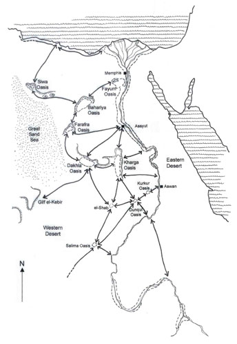
Kharga is one of the largest oases of Egypt’s Western Desert. It is located in a large depression lying 700 km south of Cairo, and 250 west of Luxor. The same depression, further west, contains the Dakhla Oasis. The Arabic names of these two oases reveal their ancient function: Kharga comes from kharug (exit) and Dakhla from dukhul (entry): they represented in fact two important stations along the desert caravan routes that allowed to enter in and/or exit from the vast basin of the Nile Valley. Their ancient strategic position was especially exploited by the Romans, who installed a legionary fort and several settlements in every large oasis along these routes.
Even if there are interesting traces of earlier periods, the majority of Kharga’s archaeological remains belong to an impressive chain of settlements with a strong military character dating to the Late Roman Period (Fourth Century AD), that are particularly interesting for a number of reasons. First of all, for the high level of preservation of their remains, and then because they also host a vast network of underground aqueducts and cultivations which were evidently installed there to support the local communities.
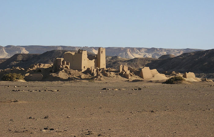
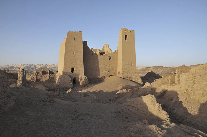
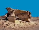
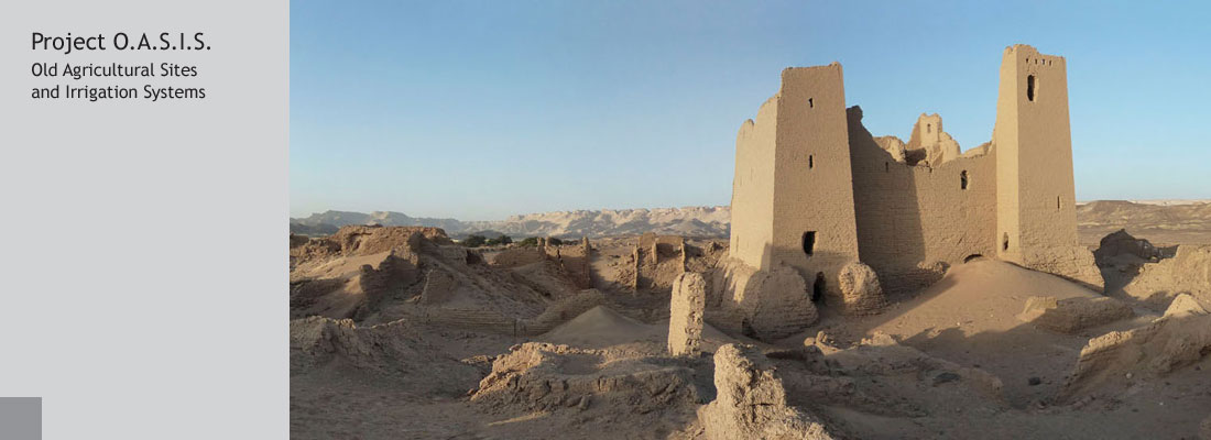
The archaeological site of Umm al-Dabadib
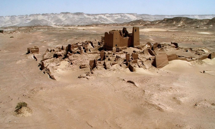
Umm al-Dabadib is a large, little-known Late Roman site. The main reason for its lack of notoriety is its position: it is in fact located in an area which is currently uninhabited, at the distance of about 50 km from Kharga’s capital.
The site was described for the first time in 1909 by the British geologist and explorer H. Ll. Beadnell, who was mainly interested in its irrigation system. Ninety years later, C. Rossi published a first description of the archaeological remains, and immediately afterwards created the North Kharga Oasis Survey (NKOS), together with Dr Salima Ikram (American University in Cairo). Aim of NKOS between 2001 and 2007 was to systematically survey the antiquities located in northern Kharga and to investigate the relationship existing among the various Late Roman sites that punctuate the oasis. In 2003 National Geographic funded the first systematic survey of the site of Umm al-Dabadib.
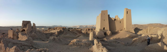
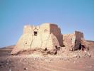
The site includes three settlements (Fortified, Northern and Eastern Settlements, the latter endowed with a pigeon tower), a Fort, a Temple, a Church, a Well, a Tower, nine cemeteries, seven subterranean aqueducts and two large cultivated areas.
The cultivations and the irrigation system
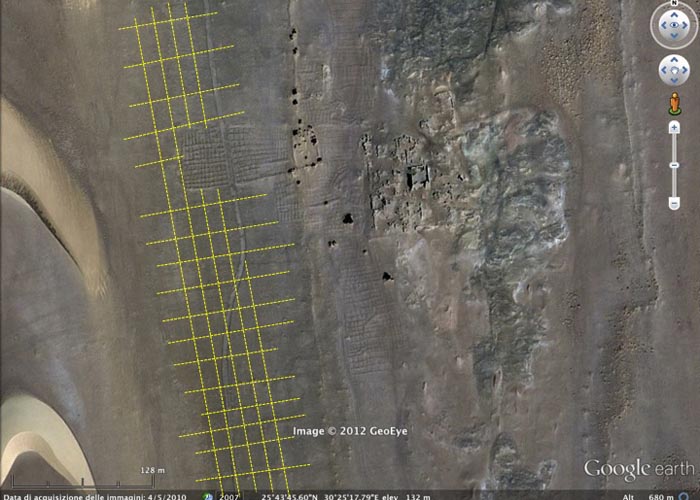
The presence of ancient cultivations associated to the aqueducts was known, but nor their extent nor their precise shape were certain until recently. Their remains, in fact, are visible for a few minutes only at dawn and sunset, when the light strikes at a flat angle, and these two brief moments do not allow to perform an accurate survey. The new resolution of the images posted by Google Earth from 2010 allowed to see all cultivations from the air in a clear way, in terms both of extent and regular layout. With the aid of these images, it is now possible to investigate the archaeological and archaeobotanical remains of both the fields and their borders.
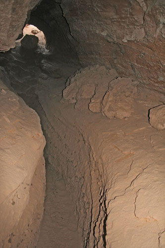
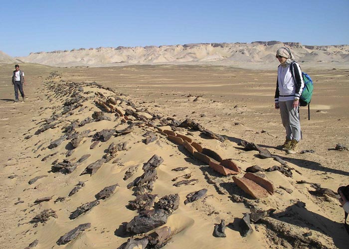
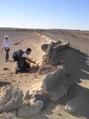
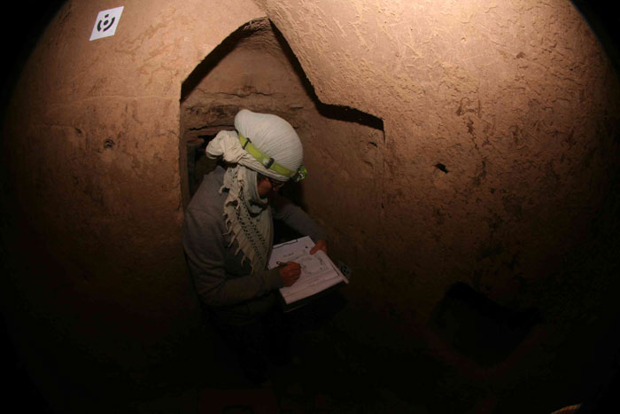
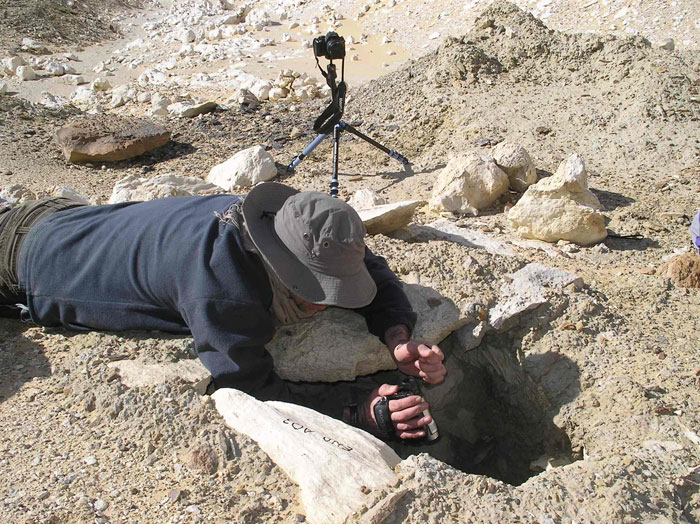
The cultivations were served by seven parallel subterranean aqueducts, of the type called qanat. They consist of gently sloping tunnels that intercept the water that freely runs in the rocks’ crevices and convey it by gravity to the surface to be cultivated. At Umm al-Dabadib these tunnels reach a length of over 3 km. Access and ventilation were granted by a regular sequence of vertical shafts, the depth of which grew constantly and reached over 40 m.
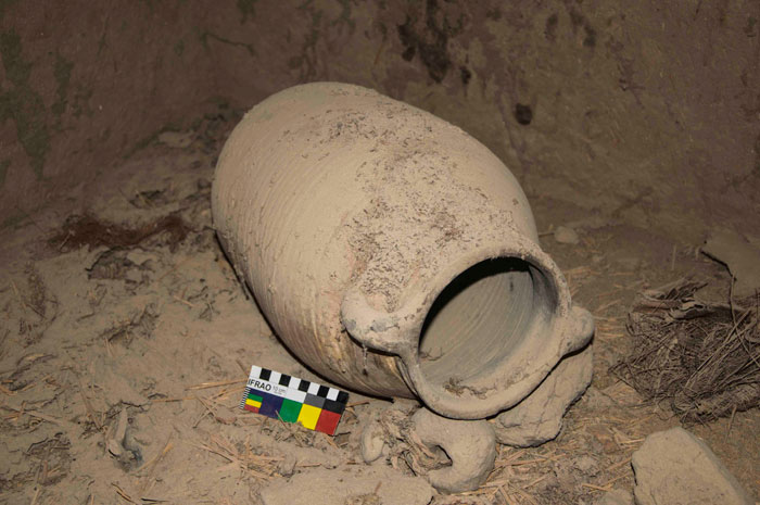
Once the water reached the area to be cultivated, it was carried as far as possible by a network of mortar or terracotta remains, that exploited the natural undulations of the terrain to maintain a minimal slope. Thanks to this system, the farthest fields were located at a distance of over 2,5 km from the mouth of the aqueducts. The fields were outlined by raised edges and mounds of stones at the corners, and still contain enough ceramic material to be used to date the remains.
The reconstruction of the Roman project
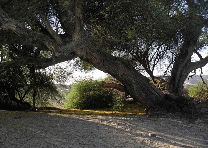
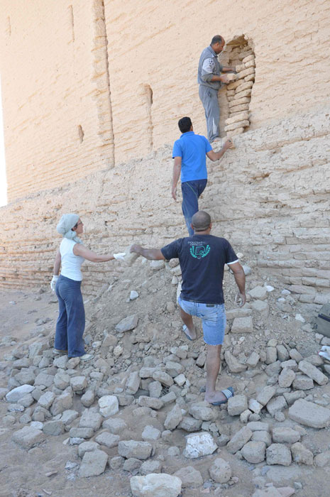
Based on the archaeological work performed in recent years the history of the site has been thus reconstructed: already in Ptolemaic times it may have hosted a strategic water station (the Well) along the Darb Ain Amur, the track that linked Kharga and Dakhla, near which a small Temple was built. The Northern Settlement, consisting of large domestic units all different and separated from one another, date to the Third Century AD. It was probably served by wells, into which large centenary acacia trees have grown over the time.The Romans operated a significant investment in the area at the beginning of the Fourth Century AD: they built a new Fortified Settlement around a Fort, an Eastern Settlement probably related to the processing and storage of agricultural products, and installed two large cultivations served by a system of seven underground aqueducts and a network of terracotta and mortar canals. Umm al-Dabadib was abandoned after about one century, at the beginning of the Fifth Century for a combination of reasons, probably including the reduction of the water discharge of the aqueducts.
We possess little information on the context of this operation of ‘colonisation’, but the excellent state of preservation of the archaeological remains allows a detailed study of the system as a whole: the new settlement, and the associated cultivations. The study of these two features is strictly related also from a physical point of view: the settlement is entirely built of mudbricks containing a high percentage of vegetal fibres, coming in part from the spontaneous vegetation and in part from the local cultivations.
Aim of OASIS is just to study these two aspects in parallel, in order to follow the steps of the ancient founders of the site: inhabited settlement and agricultural installation must have been planned together, as one could not exist without the other. Umm al-Dabadib represents a unique case in which both these elements are preserved in an excellent way. Reconstructing how the site was planned and the reasons behind its abandonment will increase out knowledge of the interaction between man and environment in an extreme location such as the limits of the inhabitable world along the vast expanse of the Sahara.
FIELDWORK
Season 2013
Sponsored by MUSA, Fondazione Collegio delle Università Milanesi, Conferenza dei Collegi Universitari di Merito CCUM.
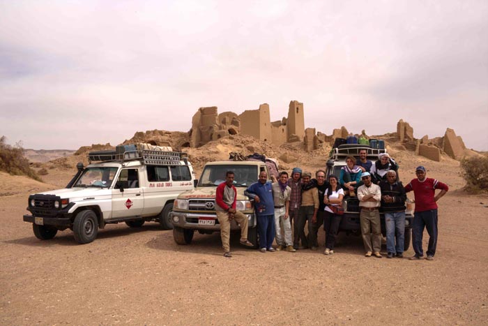
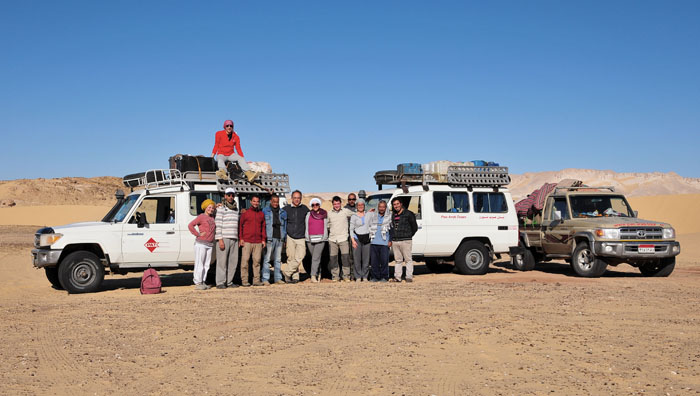
We studied the satellite images of the area, and selected the sites of Umm al-Dabadib and Ain al-Lebekha as the best potential candidates for a fieldwork investigation. We went to Kharga and explored the remains of the ancient cultivations at these two sites, and eventually selected Umm al-Dabadib as the best case study.
The 2013 team: Corinna Rossi, Giovanni Battista Chirico (MUSA), Antonello Migliozzi (MUSA), Paolo Viviani (Politecnico di Torino), Giulia Gregnanin (IULM), Francesca Bigi (Università Cattolica di Milano) e Nicoletta De Troia (Università Roma 3), Amm Rasmi (PanArab), Saleh (PanArab), Ibrahim (PanArab) and Mahmoud (PanArab), Bae (Kharga Police)
Season 2014
Sponsored by National Geographic/Waitt Institute, MUSA, Fondazione Collegio delle Università Milanesi, CCUM, acknowledged by the Italian Ministry of Foreign Affairs (Ministero degli Affari Esteri DGSP-IV).
We carried out two parallel activities: the GPS survey of the Western Cultivation and the 3D survey of the Fortified Settlement. We obtained a digital elevation model of the cultivation and reconstructed the total extent of the cultivated area, as well as its irrigations needs. We then built a 3D model of the Fortified Settlement which will be used to study in detail layout and vertical distribution of the buildings.
The 2014 team: Corinna Rossi (MUSA), Antonello Migliozzi (MUSA), Francesco Fassi (Politecnico di Milano), Alessandro Mandelli (Politecnico di Milano), Mirko Surdi (Istituto Orientale di Napoli), Anna Maria Cimino (Università Sapienza di Roma), Maria Emanuela Oddo (Università di Pavia),Hamdy Mahdy (PanArab), Shukri Hassan (PanArab), Walid Abd al-Aziz (PanArab), Mahmoud Mohammed (Kharga Police), Ahmed Moussa (Inspector of the Antiquities).

Season 2015
Sponsored by: the Italian Ministry of Foreign Affairs (Ministero degli Affari Esteri DGSP-IV), Politecnico di Milano and MUSA.
We continued our work on two parallel fronts: the survey of the agricultural system and the 3D survey of the Fortified Settlement.We completed the GPS survey of Aqueduct no. 3, carried out an assessment of the amount of archaeobotanical evidence that may be retrieved from the ancient fields, and completed a study of the local spontaneous vegetation.
We experimented the adoption of special techniques to carry out the 3d survey of the interior of the Fort, and started from the ground level. During these operations, we accessed two new rooms at ground level, where we retrieved intact objects and well-preserved archaeobotanical remains that indicate that these rooms were used as food storage.
The 2015 team: Corinna Rossi (MUSA), Antonello Migliozzi (MUSA), Francesco Fassi (Politecnico di Milano), Alessandro Mandelli (Politecnico di Milano), Essam Harby Salah (PanArab), Walid Abd al-Aziz (PanArab), Shukri Hassan (PanArab), Mahmoud Mohammed (Kharga Police), Aly Kabeesh (Inspector of the Antiquities).
STRUCTURE OF THE PROJECT
Project’s Coordinator
Dr Corinna Rossi (MUSA)
Coordinators of scientific activities
Prof. Stefano Mazzoleni (MUSA)
Prof. Cristiana Achille (3D Survey Group, Politecnico di Milano)
Team Members (2016 forthcoming expedition)
Dr Corinna Rossi, architect and Egyptologist (MUSA)
Dr Antonello Migliozzi, cartographer and botanist (MUSA)
Dr Giovanni Battista Chirico, hydrologist (MUSA)
Mr Daniele Giordano, agronomist and forester (MUSA)
Dr Francesco Fassi, engineer (3D Survey Group, Politecnico di Milano)
Mr Alessando Mandelli, architect (3D Survey Group, Politecnico di Milano)
Ms Mennat'allah al-Dorry, archeobotanist (Westfälische Universität Münster)
Mr Sherif Abdel Monaem, ceramicist (Cairo University)
Dr Salima Ikram, Egytpologist (AUC, NKOS)
Logistics
Pan Arab Tours
Project Representative in Cairo
Mr Magdy Aly
ENSUING PUBLICATIONS
- Corinna Rossi, Nicoletta De Troia, Andrea Pasqui, Antonello Migliozzi, Living in a fringe environment: three Late Roman settlements in the Kharga Oasis (Egypt’s Western Desert), Journal of Roman Archaeology, 2022, doi:10.1017/S1047759421000829.
- Francesco Fassi, Corinna Rossi and Alessandro Mandelli, 2015. ‘Emergency survey of endangered or logistically complex archaeological sites’, Int. Arch. Photogramm. Remote Sens. Spatial Inf. Sci., XL-5/W4, 85-91, doi:10.5194/isprsarchives-XL-5-W4-85-2015.
- Corinna Rossi, ‘OASIS 2014: Archaeological Mission at Umm al-Dabadib (Kharga Oasis). Preliminary Report - Part I: the survey of the Western Cultivation and its aqueducts’, forthcoming in Mitteilungen des Deutschen Archäologischen Instituts Kairo 69 (2016).
- Corinna Rossi, Antonello Migliozzi, Francesco Fassi, Alessandro Mandelli, Giovanni Battista Chirico, Cristiana Achille, Stefano Mazzoleni, ‘Archeologia, scienza e tecnologia: lo studio del sito tardo-Romano di Umm al-Dabadib (Oasi di Kharga, Egitto)’, full paper forthcoming in the proceedings of L.O.S.A.I. (Laboratori Open su Scienza, Arte e Innovazione), 28-31 Maggio 2015.
CONTACTS AND ACKNOWLEDGEMENTS
Contacts
This email address is being protected from spambots. You need JavaScript enabled to view it.
Photo credits
C. Rossi, P. Viviani, F. Fassi, A. Migliozzi
Acknowledgements
We wish to thank HE the Minister of the Antiquities of Egypt Prof. Mamdouh al-Damaty, the Ministry of the Antiquities/Supreme Council for the Antiquities, and the Chief Inspector of Kharga Mr Ibrahim Bahgat and his team for their support.
Thanks to Mr Ahmed Moussa and the Pan Arab Tours office and crew for being always ready for action.